3:51:49 PM

January 2025
SuMoTuWeThFrSa
---1234
567891011
12131415161718
19202122232425
262728293031
 

Italian version


Index      Index
     
English version by:
Jason (Iacovino) Pierce,
New Jersey.
jason_pierce@yahoo.com


SITE MAP


HISTORY OF MORRONE


The Samnites
The Romans
The Normans
Historical chronology
The Charter of Carlo II d’Angiò
The Census of 1532
The appraisal of Morrone of 1593
Historical Events
1614 visit of Monsigor Eustacchio
1734 visit of Monsignor Tria
Luigi Cinelli
Miscellaneous
Parochial Archive
Customs
Traditions
Weights and Measures
Markets and Fairs
The Feast of San Giuseppe
The Territory
Migratory route for herds
Surnames and Nicknames
Vanished surnames
Experts and Masters from Morrone
Famous People
Santa Maria in Casalpiano
Franco Valente: Casalpiano
The Toponymy of Morrone

Rural Life
A stroll around Morrone
Panoramic photo
Old prayers
Morronese cookbook
Postcards from Morrone
The portals of house
Morronese crafts
 

VARIED PAGES


Morrone seen from:
Poetri in morronese dialect
 

YESTERDAY AND TODAY


Old photo album
Current photo album
Photos from viewers of the site
Songs from Morrone
Earthquake from Morrone
My page

I Miaban
The Newspaper of Morrone
 

THE MOLISE


INDEX MOLISE

The Molise territory
Molise in the norman period
The road system
Pre-norman fortifications and settlements
Urban development: the church and the castle
Relations with the Church
Architecture in norman times
Fortifications and castles
Molise at the time of the crusades
Molise and the Adriatic
The fortifications today
 

The South and the Unification of Italy

AWARDS


Exchange link

Screen saver of Morrone

©COPYRIGHT


Apartment for rent

 I am looking for Morronese relativen in America

LA STORIA DI MORRONE


I Sanniti
I Romani
I Normanni
Cronologia storica
1303 Carlo II D'Angiò
I censimenti dal 1532
L'apprezzo del 1593
Avvenimenti
1614 Mons. Eustacchio
1734 Mons. Tria
Inchiesta Murattiana
Miscellanea
Archivio parrocchiale
I costumi
Le tradizioni
I pesi e le misure
I mercati e le fiere
La festa di San Giuseppe
Il territorio
Il tratturo
I cognomi e i soprannomi
I cognomi scomparsi
I maestri
Le persone famose
S. Maria in Casalpiano

Cli scavi di Casalpiano
Franco Valente spiega Caslpiano
Franco Valente: Casalpiano
Franco Valente: Araldica
La chiesa Madre
I Feudatari di Morrone
Toponimo di Morrone
L'Italia Meridionale
Vita rurale.
Quattro passi per Morrone
Panoramiche grandangolo
Antiche preghiere
Ricettario morronese
Cartoline da Morrone
I portali e lavori in pietra
Vecchi oggetti morronesi
lettere d'oltreoceano
 

VARIE


Morrone visto da:
La poesia dialettale
 

MORRONE IERI E OGGI


Raccolta foto antiche
Raccolta foto recenti
Canzoni morronesi
foto inviate da Voi
Il terremoto a Morrone
Altri siti Molisani
La mia pagina

I Miaban
Il Giornale di Morrone
 

IL MOLISE E
REGIONI CONFINANTI


INDICE MOLISE

Il territorio del Molise
L'epoca Normanna
Le vie di comunicazione
Fortificazioni e insediamenti prenormanni
Sviluppo urbano: la chiesa
e il castello
I rapporti con la Chiesa
L'architettura Normanna
Opere fortificate e castelli
Il Molise e le crociate
Il Molise e l'Adriatico
Le opere fortificate oggi

INDICE ABRUZZO

LA CAMPANIA


IL SUD E L'UNITA'D' ITALIA

RICONOSCIMENTI


Pagina link

Screen saver di Morrone

©NOTIZIE SUL COPYRIGHT


i

Il comune informa
The town hall informs


comune.morrone@libero.it
www.morronedelsannio.eu


Notizie da Morrone. A cura di: Mariassunta Faccone & Valentina Saltarelli


LIBRO OSPITI


info@morrone.com
Webmaster & Admin Site:
Giuseppe Buonviaggio


THE MOLISE.
3
The road system

English version by Jason
Italian  version

The road system in roman and medieval times

Roman roads, according to ancient sources, appear to have been distributed along two parallel axes, one skirting the coast and the other running along the ridge of the Matese massif. These two main thoroughfares were complemented by a cross-road that ran parallel with the course of the river Biferno, plus a road that led from Isernia-Aesernia, through Venafro-Venafrum, to the Via Latina. Roman roads tend to follow previous courses and often overlap ancient sheep-tracks. The Via Minucia, for example, coming from Castel di Sangro-Aufidena, follows the Pescasseroli-Candela sheep-track and becomes the axis for new Roman urban settlements (Bojano-Bovianum, Sepino-Saepinum, Isernia-Aesernia). With the fall of the Roman Empire the viae publicae ceased to be maintained and were gradually replaced by other routes that bear witness to the widespread fragmentation of the territory.  
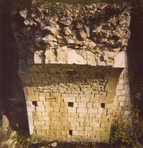
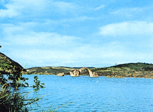
The Traiano-Frentana, which is conventionally identified by the name of Litoranea (coastal road), stretched from the north to Larino-Larinum. Its course is followed in part by the Aquila-Foggia sheep-track and the modern road system. The present state highway 17 follows to a large extent the Pescasseroli-Candela sheep-track. A road connected Bojano-Bovianum with Larino-Larinum, passing through the ad Canales and ad Pyr(um) stations. Remains of bridges still survive along these roads: the Limosano bridge, the Rotto bridge, the Giano Camense bridge, the bridge on the Sordo river and others. A hump-backed triple-arch bridge (late 13th cent.) was recently submerged by the reservoir created by the Liscione dam on the river Biferno.  

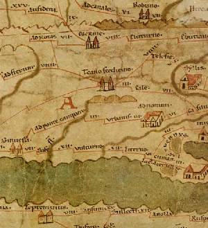
The main sources on the road systems are the Itinerarium Antonini Augusti, with detailed lists of connected towns and distances by road ; the tabula Peutingeriana (12th century reproduction of a 4th century road map of the Roman Empire) and the Ravennati Anonymi Cosmographia.

Bagnoli del Trigno (Cannavite) Civitanova del Sannio

Tabula Peutingeriana.
 
Guardialfiera: ponte della Reginella
(invaso Liscione)


© 2011 www.morronedelsannio.com - All right reserved.
webmaster@morrone.com